Manpack Configuration
Airborne Configuration
Product Description
RFHunter® is a passive Radio-Frequency (RF) direction-finding and monitoring system that provides signal detection and analysis, emitter direction finding, and geolocation capabilities. The system is lightweight, compact and easily deployable, designed for highly mobile but extremely accurate localisation of radio frequency emissions. It can be quickly deployed in a wide range of operational environments to provide real-time passive situational awareness to diverse tactical defence and security operations, either as a standalone tactical sensor or integrated with a wide range of Electronic Warfare platforms, command-and-control systems, and Battle Management Systems (BMS), enabling coordinated operations and enhanced situational awareness.
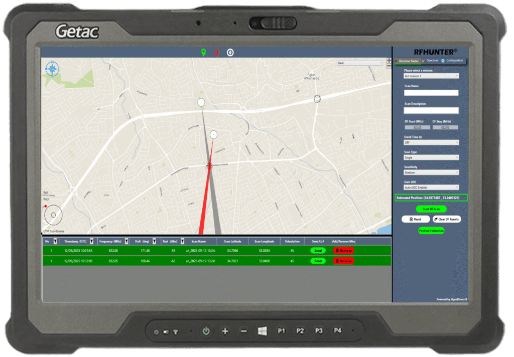
The operation of the direction-finding (DF) system is based on the accurate determination of the direction from which incoming radio signals originate. The DF antenna passively receives radio signals and, by analysing the phase and amplitude differences between the antenna elements, determines the direction of the signal source, commonly referred to as the signal bearing. A single bearing measurement indicates the direction of an emitter but does not provide its exact location. To geolocate an emitter, bearing measurements from two or more physically separated positions are combined through triangulation.
The operation of the system is done through the RFHunter® Command and Control (C2) application which runs on a ruggedised tablet and provides the operator’s primary interface for mission planning, spectrum monitoring, data management, direction-finding operations and system configuration. The results are displayed graphically and numerically on the C2 application, enabling the operator to detect, analyse, and hear the signals, and identify the bearing and geolocation of the detected signal emitters.
These system capabilities enable a broad spectrum of applications that enhance situational awareness across defence, law enforcement, and security operations, including the detection, analysis, and geolocation of communication emitters, as well as the tracking and identification of transmitting crewed and uncrewed platforms, while its high portability, precision, and real-time performance make it a mission-critical asset for threat identification, spectrum dominance, and rapid operational response across the electromagnetic environment.
Product configurations

MANPACK
Single-operator dismounted deployment. Self-powered, self-navigating, self-contained. No external infrastructure required.
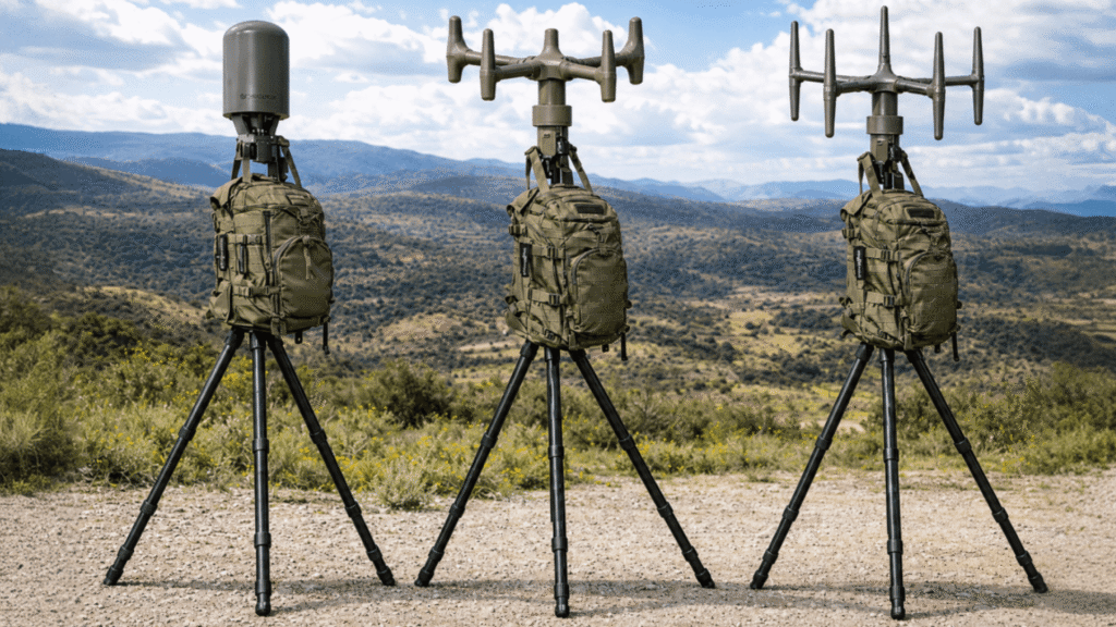
TRIPOD-MOUNTED
Static deployment for sustained monitoring from observation posts. The operator controls the system from a concealed position.
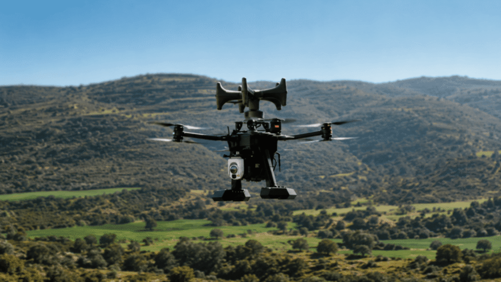
DRONE / UAV-MOUNTED
Airborne reconnaissance from unmanned platforms. Elevated coverage of areas inaccessible to ground-based systems.
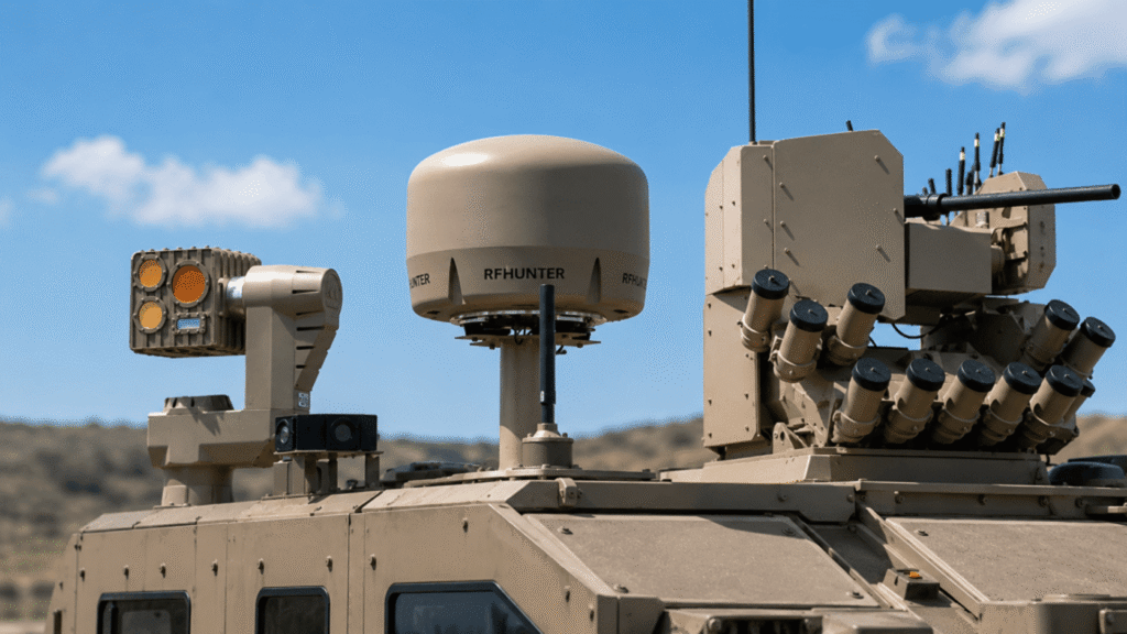
VEHICLE / MOUNTED
Continuous direction finding from mobile ground platforms. Remote monitoring and control without physical access to the vehicle.

BOAT / USV-MOUNTED
Maritime and riverine deployment for coastal surveillance and harbour protection.

Main Features
- Fully passive operation — the system does not transmit and does not alert the emitter to its presence
- Real-time signal detection and bearing determination using correlative interferometry
- Emitter geolocation through triangulation, with estimated position displayed on a dynamic map
- Wide operating range of 30 MHz to 3,800 MHz
- Detection of burst and frequency-hopping signals
- Simultaneous detection and bearing of multiple signals across the operating spectrum
- Detectable signal types: CW, AM, FM, and SSB signals
- Automatic self-positioning and self-orientation without manual input
- Ruggedised tablet with Command and Control application displaying bearing lines on an interactive tactical map
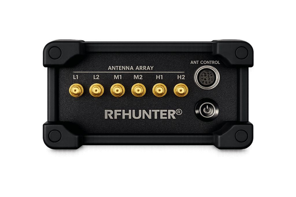
- Three mission-specific DF antennas covering Low, Mid, and High frequency bands with quick-release antenna exchange in the field
- Designed for integration with a wide range of Electronic Warfare platforms, command-and-control systems, and Battle Management Systems
- Spectrum monitoring with real-time signal reception, demodulation, and audio output (optional)
- Multi-unit networking for collaborative emitter geolocation (optional)
Command and Control Application
The RFHunter® C2 application runs on the ruggedised tablet and provides the operator’s primary interface for mission planning, direction-finding operations, spectrum monitoring, data management, and system configuration.
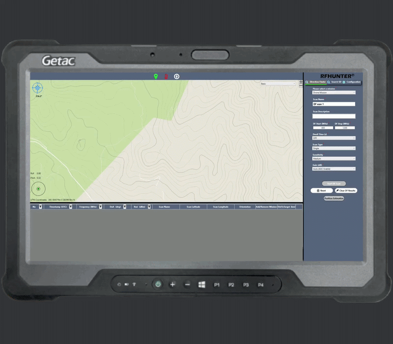
DIRECTION FINDER
- Mission-based scan workflow: wide-band survey to identify signals of interest, then narrow scan for precise bearing determination
- Targeted frequency watchlist for rapid monitoring of known signals of interest
- Single and continuous scan modes for one-time survey or persistent electromagnetic monitoring
- Real-time bearing results displayed as colour-coded lines on an interactive tactical map with live position tracking
SPECTRUM MONITOR
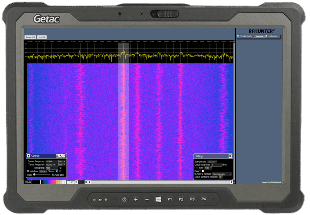
- Real-time FFT spectrum display and waterfall spectrogram for electromagnetic environment survey and signal investigation
- Six demodulation modes (WBFM, NBFM, AM, USB, LSB, CW) with real-time audio output for aural signal assessment
- Configurable sample rate and FFT resolution for tailored signal analysis
- Operates on an independent hardware path — DF scan continues running in the background
Use Cases:
DF/COMINT Operations
Tactical direction finding and communications intelligence support.
Special Forces Operations
Lightweight passive system for dismounted operations in harsh terrain.
Coastal/Border Surveillance
Detect and localise unauthorised communications along borders and coastlines.
RF Target Geolocation
Triangulate emitter positions from multiple bearing measurements.
Illegal Interference Detection
Locate unlicensed or interfering transmitters disrupting communications.
Automatic Threat Detection
Unsupervised continuous spectrum monitoring with automated alerting.
Search and Rescue Operations
Bearings to distress beacons, handheld radios, and locator devices.
Drone/UAS Direction Finding
Detect and localise drone operators; integration into CUAS systems.